High-resolution map plots Europe's climate-driven farm decline
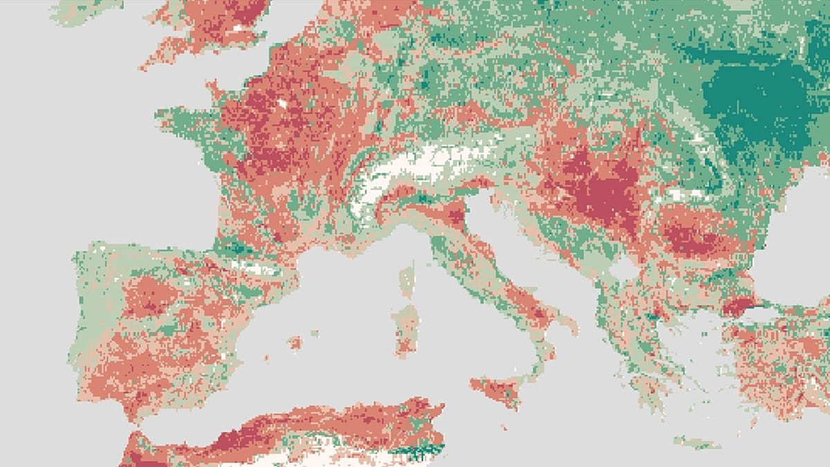
A new high-resolution mapping tool reveals exactly where European farmland will lose productivity to climate change, warning that even regions that gain arable capacity will face economic friction.
Researchers at the Institute for Economic Analysis in Barcelona have launched a platform that calculates how climate change will erode global agricultural productivity down to a 9.3-kilometre grid. The tool, known as the Climate-induced Agricultural Decline Index (CADI), uses historical crop yields from the UN's food agency and European Copernicus climate records to project farming declines through to 2100.
The model isolates the pure impact of shifting weather patterns by holding crop choices constant at 2020 levels and assuming no human adaptation measures are taken. Coordinated by Laura Mayoral and Hannes Mueller, the index provides a strict baseline of physical climate risk, making it easier to identify which specific local economies are structurally vulnerable to warming.
Europe exhibits a familiar but sharply defined north-south divide. While Scandinavia, Scotland and the Alps gain agricultural potential, southern Europe declines. Spain perfectly illustrates this internal fracture: the Cantabrian coast, Galicia and the Pyrenees become more productive, while the interior and central-eastern peninsula suffer heavy losses, reproducing global imbalances within a single national border.
Globally, the observed damage is already highly concentrated. One in six croplands lost more than a tenth of their potential output between 2001 and 2020 compared to the prior two decades. If temperatures rise by a medium-high trajectory of 2.1°C by mid-century, almost half the world's population will live in areas that have lost at least 5% of their farming capacity.
For agricultural investors and commodities markets, the most significant finding is that rising productivity in new areas creates its own economic frictions. As viable farmland shifts, capital, water rights and land use must be reallocated to entirely different regions. This triggers competition for resources between areas that previously did not compete, threatening to distort domestic supply chains and devalue assets in declining zones.
The researchers stress that CADI is intended to guide preemptive economic planning rather than merely forecast doom. By identifying future vulnerability at a granular level, the platform allows governments and the private sector to target adaptation investments—such as deploying new crop technologies or relocating production—before falling yields destroy rural incomes or trigger forced population movements.